The best animated map video makers in 2026
Nine tools for animated map videos, compared: narrated or silent, made by AI or keyframed by hand, routes, data by country, borders over time, and price.
By the Chasca team 10 min read
The best animated map video maker depends on whether you want a finished, narrated explainer or a clip you build yourself. For a narrated map video made from a topic, an itinerary or your own script, with routes drawn stop by stop, regions lighting up and the year counting on, we’d pick Chasca’s Map story skill, which we make. Mapflyover is the other tool that narrates map videos with AI, as 3D flyovers. Google Earth Studio makes the most cinematic satellite flyovers for free, but by hand and not for ads; TravelBoast makes travel route clips on a phone; Flourish makes interactive and data maps; After Effects with GEOlayers 3 and DaVinci Resolve can make anything if you animate it yourself.
How did we choose and check these tools?
- What’s included: the tools ChatGPT named when we asked it for the best tool to make animated map videos and geography explainer videos, and one AI map-clip maker we found in the niche.
- How we checked: we read each tool’s own product, pricing, help and terms pages on 14 November 2026, or its own app-store listing where the site shows no prices. Prices are US list prices. Some pages refused automated reading, so we read a saved copy of the same page; where we couldn’t confirm something, we say so. Prices change often, so check before you buy.
- Our bias: we make Chasca. We say plainly where another tool is the better choice, and every claim about another tool links to its own pages.
- Not included: general AI video makers that show stock footage over a map-shaped topic, and online map viewers without video.
The nine tools at a glance
| Tool | What you get | How it’s made | Narration | Borders over time | Free | Paid from |
|---|---|---|---|---|---|---|
| Chasca (Map story) | A narrated map video: routes, regions, pins, data by country, the year | AI, from a topic, an itinerary or your script | Yes, 30 narrators or your own voice | Approximate areas that change with the years | 2 videos up to 1 minute, watermarked | $9.99 a month (30 minutes) |
| Mapflyover | 3D map flyovers with narration and captions | AI (3 videos per account), then your own agent or the editor | Yes, generated or your recording | No: today’s borders only | 2 exports a month, 90 s, 720p, marked | $20 a month |
| Google Earth Studio | Satellite and 3D flyovers | Keyframed by hand | No | No | Free, access by request | Free |
| Flourish | Interactive maps and charts; video from stories | Templates and your data | No; videos have no sound | From time columns in your data | Free, public with credit | Through Canva Business, $250 a year a person |
| TravelBoast | A trip route on a 3D map (phone app) | Pick a vehicle, enter the route | Not mentioned | No | Free with ads | $5.99 a month (US App Store) |
| Mapbox | Interactive maps for developers | Code | No | In code, with your data | Free tiers by usage | Usage-based; video rights through sales |
| After Effects + GEOlayers 3 | Any map animation | Keyframed by hand | No | By hand | 7-day trial | $22.99 a month plus $329.99 |
| DaVinci Resolve | Video editing and effects | By hand | Text to speech | By hand | Free | Studio $295 |
| MapAnimation.io | Short AI map clips, up to 60 s | AI, from a prompt | Not offered | Not stated | Trial with a card | $12.99 a month |
Chasca: best for a narrated map story from a topic, an itinerary or a script
Chasca’s Map story skill turns a voyage, a trade route, an empire, a trip itinerary or figures by country into a narrated, animated map video, or follows your own script word for word.
- The map moves as it is told: the camera flies to where the story goes, routes draw on as each stop is named, with a ship, a plane, a train or a caravan riding them, regions light up, and the year counts on in a corner or along a timeline.
- Real places, never guessed: every city, coast, river and border comes from real map data. Sea routes go around the land by themselves, and through the Suez or Panama Canal only when the story says so; a place that isn’t in the map data is left out, and the video’s page says which.
- The past and your figures: empires and kingdoms of the past are drawn as approximate areas, hatched and labelled with “about”, that grow and shrink with the years. Figures by country become shades with a legend, from your own numbers only.
- Watch out for: there are no satellite pictures or street maps, the camera stops at about a region’s size, and old borders are approximate areas, not exact lines. Videos are 16:9 and run 30 seconds to 10 minutes on paid plans.
- Voice and price: any of 30 narrators in 79 languages, or your own voice, with names on the map in the video’s language and Arabic right to left. Two free videos up to a minute each, watermarked, with no card; then $9.99 a month for 30 minutes (pricing).
Mapflyover: best for a narrated 3D flyover
Mapflyover turns a sentence or a script into a 3D map flyover video, with the camera flying over real terrain and boundaries, generated narration or your own recording, and word-timed captions.
- Good for: geography Shorts and explainers with a flying camera: regions filled with colour, a statistic or a picture, routes and arrows that draw on, a boat or a plane moving along a path, ten base looks including satellite and an aged-paper style, and countries coloured from a table. Six templates cover history, top lists, comparisons, routes, travel and country profiles. MP4 in 9:16 or 16:9.
- Watch out for: the built-in “Create with AI” makes 3 videos per account; after that you connect your own AI agent and pay for its model, and only you can export. Borders are today’s only: the history page suggests importing your own outlines for the past. Videos render on your own device, satellite exports need your own free Mapbox token, and you own your exports for commercial use while you subscribe.
- Free and price: two exports a month, up to 90 seconds, 720p, with a mark. Pro is $20 a month (30 exports, up to 5 minutes, 1080p, no mark) and Studio $70 a month (up to 15 minutes, 4K).
Sources: home, features, history and documentary videos, pricing and terms.
Google Earth Studio: best for a free satellite flyover, keyframed by hand
Google Earth Studio is a browser animation tool for Google Earth’s satellite and 3D imagery, built on keyframes, with five quick starts such as Zoom-To, Point-to-Point and Orbit.
- Good for: cinematic flyovers of real places at up to 4096×2304, for documentaries, news and education.
- Watch out for: there is no script, narration or captions, and routes, labels and pins are expected to be added in After Effects. Local renders are image sequences you turn into a video yourself; MP4 comes only from cloud renders, up to 18,000 frames a day. It runs in desktop Chrome, access is granted case by case, the attribution must stay on screen, and Google’s guidelines don’t allow its content in ads or promotional videos.
- Free and price: free.
Sources: Earth Studio, rendering, cloud rendering, attribution, FAQ and geo guidelines.
Flourish: best for interactive maps and data by country
Flourish makes interactive charts, maps and stories without code: choropleths, point maps, a 3D globe, an animated 3D map for flows, routes or change over time, and more.
- Good for: data maps for the web, from your own data, with change over time from time columns in it.
- Watch out for: it is built for interactive embeds. Video comes only from stories, as a premium feature Flourish switches on, without sound and up to 300 seconds; you add narration elsewhere. You find and prepare the data yourself.
- Free and price: free for public projects, with Flourish’s credit. Paid access comes with Canva Business, $250 a year per person, or a quote.
Sources: maps, pricing, stories as video and Canva pricing.
TravelBoast: best for a travel route clip on your phone
TravelBoast is an iPhone and Android app that animates a trip on a 3D map: choose a vehicle, enter the route (or import GPX or Google Maps), and save the video to share.
- Good for: short trip videos for Instagram and TikTok, with hundreds of vehicles and your own photos and videos added along the way.
- Watch out for: it is a travel route app: its pages mention no narration, captions, text labels or data maps, and don’t state the video’s format or resolution.
- Free and price: free with ads. On the US App Store, subscriptions are $2.99 a week, $5.99 a month or $17.99 a year, and single vehicles $1.99 each.
Sources: TravelBoast and US App Store.
Mapbox: best for developers building their own map animation
Mapbox is a mapping platform for developers: Mapbox Studio designs map styles and GL JS draws interactive maps, with official examples of a point moving along a route, a time slider and a choropleth.
- Good for: a custom map animation built in code, with full control of the style.
- Watch out for: there is no video product: a video means capturing frames in your own code, and Mapbox’s own blog shows how. Its pricing page restricts using its map content in video except as its product terms allow, with extra rights through sales, and maps carry Mapbox and OpenStreetMap attribution. No narration.
- Free and price: free tiers each month (50,000 web map loads), then usage-based.
Sources: Mapbox Studio, animate a point along a route, cinematic route animations and pricing.
After Effects with GEOlayers 3: best for a fully custom map animation
GEOlayers 3 is an After Effects extension that draws and animates maps inside After Effects: borders, streets, rivers, places and regions, driving routes, labels from templates, and styles driven by CSV data.
- Good for: motion designers who want any map animation they can imagine, in 3D, with the rest of After Effects around it.
- Watch out for: everything is keyframed by hand and there is no narration or script. Map data for commercial projects is your responsibility; the plugin points to MapTiler, whose free plan is non-commercial. Costs add up: the plugin, the After Effects subscription and optional 3D plugins.
- Free and price: After Effects is $22.99 a month on the annual plan, after a 7-day trial; GEOlayers 3 is $329.99 for a single user (as listed on 22 October; we couldn’t read the live page), about $606 for the first year together.
Sources: GEOlayers 3, After Effects plans and MapTiler pricing.
DaVinci Resolve: best for editing a map video you made elsewhere
DaVinci Resolve is a video editor with colour, effects (Fusion) and audio in one app; version 21 adds an AI speech generator for text to speech.
- Good for: cutting, colouring and voicing a map video from footage you already have, on a free editor.
- Watch out for: it has no map data or map templates: every map animation is built by hand from assets you supply.
- Free and price: free; DaVinci Resolve Studio is $295 list (shown at $236 on 14 November).
Sources: DaVinci Resolve, Studio and what’s new.
MapAnimation.io: best for a short silent map clip from a prompt
MapAnimation.io makes map animations from a plain-English description: its AI handles the camera, zooms, highlights and rendering, with no timeline to edit.
- Good for: a clip of up to 60 seconds in 16:9, 9:16 or square, from 1080p to 4K, to drop into a video you narrate elsewhere; commercial use without royalties on paid plans.
- Watch out for: its pages offer no voice or script, previews and changes cost credits, and its example titles about changing borders don’t say where the borders come from.
- Free and price: a 3-day trial with a card. Starter is $12.99 a month, or $129.90 a year.
Sources: MapAnimation and pricing.
How do you make a narrated map video with AI?
With Chasca:
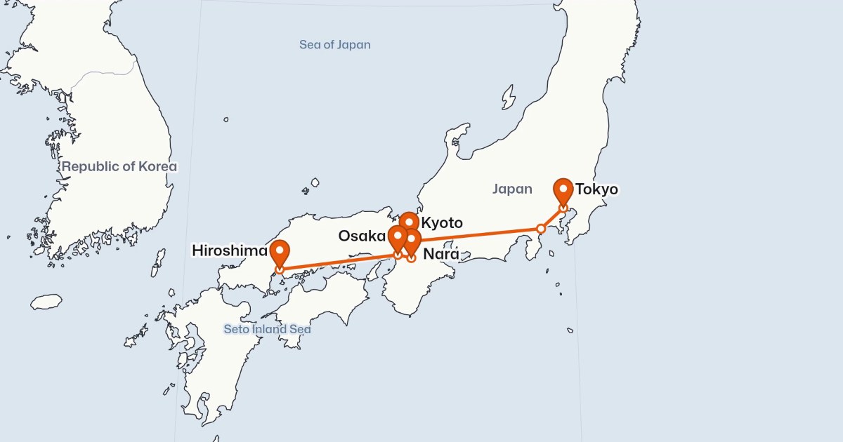
- Describe the story: a voyage (“How did Vasco da Gama reach India by sea?”), a trip (“10 days in Japan by train: Tokyo, Hakone, Kyoto, Nara, Osaka, Hiroshima”), an empire over time, or figures by country. Or paste your own script and choose “My words, word for word”.
- Open the Map story skill, and pick the light or the dark map.
- Pick a narrator, or your own voice, and a language. The names on the map follow it.
- Check the video’s page: it lists any place the map couldn’t show, and any fact worth a second look.
- Share it, or make the next one.
More in history and geography on a map that moves.
Which one should you pick?
- A narrated map story from a topic, an itinerary or your script, with routes, regions and the year changing as it is told: Chasca.
- A narrated 3D flyover over real terrain: Mapflyover.
- A cinematic satellite flyover for a documentary or a lesson, not an ad: Google Earth Studio.
- An interactive or data map for a website: Flourish.
- A quick trip route clip on your phone: TravelBoast.
- A map animation built in code: Mapbox.
- Any map animation at all, keyframed by a motion designer: After Effects with GEOlayers 3.
- Editing and voicing a map video you already have: DaVinci Resolve.
- A short silent clip from a prompt: MapAnimation.io.
Questions people ask
It depends on the video. For a narrated explainer made from a topic or a script, with routes, regions and the year changing as it is told, we'd pick Chasca's Map story skill, which we make; Mapflyover also makes narrated map videos, with 3D flyovers. For a cinematic satellite flyover, Google Earth Studio is free but keyframed by hand and not allowed in ads. For a travel route clip, TravelBoast. For an interactive or data map, Flourish. For anything custom, After Effects with GEOlayers 3.
Yes. Chasca's Map story skill writes the narration (or reads yours word for word), voices it, and animates the map in step with it, in one go. Mapflyover's built-in AI makes up to 3 videos per account; after that you connect your own AI agent. MapAnimation.io makes short AI map clips from a prompt, without a voice.
Chasca draws empires and kingdoms of the past as approximate areas that grow and shrink as the year counts on, with a timeline strip. Flourish animates change over time from time columns in your own data. Mapflyover shows today's borders only and suggests importing your own outlines for the past. In After Effects with GEOlayers 3 you animate them by hand.
No. Google's geo guidelines allow Earth and Earth Studio content in news, documentaries, education and monetized online videos, with the attribution kept on screen, but not in advertising, commercials or promotional films for a product, business or organisation.